Sunday Science: Boston’s Colonial Universities Grab Land for Profit, War, and Medical Apartheid
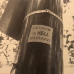
Universities on Turtle Island, as la paperson writes, “are land-grabbing, land-transmogrifying, land-capitalizing machines.” Indigenous land theft, and profits from slavery, enabled these universities to be built in the first place – and they still collect profits from stolen lands.
With this accumulated capital, major US universities have become colonial real estate agents. Harvard University, notably, owns land all over the world – from vineyards in Washington state to farmlands in Brazil, South Africa, New Zealand, and Romania. Harvard’s land-grabbing machine has harmed Indigenous communities, poisoning their water and crops in Brazil, and denying access to burial sites and pasture land in South Africa.
In the Boston area, too, Harvard and other universities grab land and put it to work for private profit, war, and perpetuation of medical apartheid. These land grabs increase property values and rents, fuel the displacement and ethnic cleansing of local communities, and make it harder for grassroots organizations to survive in the city.
Universities take control of city politics and grab land
Today, Greater Boston’s major universities control many expensive land parcels (Figure 1). As of 2021, the estimated total market value of Harvard’s lands and buildings in Massachusetts comes to a staggering $9.8 billion. Harvard is followed by MIT, whose lands and buildings are “valued” at $6.7 billion, and Boston University ($2.7 billion). In Cambridge alone, Harvard owns 190 tax-exempt acres, while MIT owns over 150. These massive footprints are the spoils of an 80-year expansion strategy. Harvard and MIT have built up large “land banks” – property holdings so vast that universities’ policies can harm entire communities.
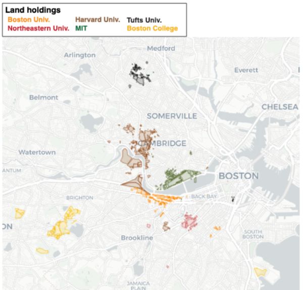
Figure 1: University land grabs. Land holdings of Boston-area universities (as of 2021) with the most highly “valued” properties (data from MassGIS).
To gain control of the land, universities have helped rewrite the rules of Cambridge’s government. Key to this was the implementation of Plan E: an anti-democratic system in which a small number of city councilors are elected from across the entire city, and where the financial power to implement council decisions is held by an unelected city manager. Plan E replaced the more decentralized ward-based system that, despite its problems, arguably kept powerful entities like Harvard from expanding into new areas. The brainchild of Harvard academics, Plan E enabled the university to expand by pushing its favored candidates into city council. Although Plan E was met with fierce opposition by local groups who denounced it as fascistic in the late 1930s, it was eventually adopted in 1940.
Universities used the new rules to push racist “slum clearance” policies. At the end of WWII, Cambridge was a working-class, immigrant city: it was still home to factories, organized labor, and racially integrated neighborhoods, despite the redlining of its historically Black neighborhoods. As the war ended, however, universities seized the opportunity to turn what they saw as “slums” into research and development centers for the reconfigured war industry. Harvard’s push for urban removal (“urban renewal”) was also motivated by a nakedly racist white fear of the surrounding communities, with one Harvard student claiming the university was “in the position of a man about to be eaten by cannibals.” In 1956, Cambridge’s unelected city manager (empowered under Plan E) appointed José Luis Sert, dean of the Harvard Graduate School of Design (GSD), as chair of its planning board to steer urban renewal in the city. Collaborating with municipal offices filled with their alumni, MIT and Harvard’s urban planning departments advocated bulldozing entire neighborhoods, especially majority Black and Brown neighborhoods. These neighborhoods were replaced by developments like Kendall Square that house the companies and academics working for the US war machine, with Pentagon sponsorship.
As universities expanded, the influx of students and faculty put pressure on surrounding neighborhoods. Between 1960 and 1970, the student populations of Harvard and MIT increased by 35%, and by 1968, 4,000 units of Cambridge housing were occupied by Harvard faculty, staff, and students, with another 2,000 occupied by MIT students and staff. Over the same decade, Harvard bought 834 Cambridge housing units and tore down 172. One frontline of the offensive was Riverside, a small neighborhood between Harvard’s campus and Central Square, threatened for destruction under the Inner Belt plan. Since Riverside’s school population was 50.5% non-white, replacing the school building to expand student capacity was rationalized as a way to “restore racial balance.” The architecture firm of the Harvard GSD dean, Sert, Jackson & Associates, drew up plans that required demolishing the surrounding homes. At a public meeting, residents voiced their outrage: “As far as we’re concerned, we won’t be here to enjoy a new school,” said David Bailey. Lucille Crayton questioned where people whose homes were taken would go: “It looks like they’d let us stay there. There’s only a few colored left,” she said, adding “I’m fighting to the end.” By the time the new school opened in 1976 as Dr. Martin Luther King, Jr. School, 30 families had been displaced.
Anti-displacement groups working in coordination with student activists also pressured Harvard to halt the evictions caused by its expansion. In 1970, 300 community members and students disrupted Harvard’s graduation ceremonies to demand the last open space on the Charles River waterfront, the Treeland Bindery site in Riverside, be reserved for 100 low-income housing units. Under pressure, Harvard bought an alternate site for 32 low-income townhouses. As local politician and Riverside resident Saundra Graham put it, “We successfully stopped Harvard from buying up the whole community – they only got half of it.”
Since then, universities have continued to accumulate properties by playing the real estate market. They buy housing for their faculty, students, and staff, which drives up home prices and rents – which in turn boosts the value of universities’ real estate holdings. In the 1970s and ‘80s, Harvard Real Estate Inc. ramped up its approach, seeking to buy any properties “available at a reasonable price,” and introducing an option plan for faculty homebuyers under which Harvard retained the right to buy upon resale. As landlords, Harvard and MIT often bypassed rent control when it existed, and pushed hard for its abolition in the later ballot fight.
By the 1990s, these university-backed ethnic cleansing programs had filled Harvard’s surrounding neighborhoods with affluent white residents who were no longer happy with university expansion – so the city enacted policies to limit it. But since Cambridge rent control was abolished in 1995 through the actions of the militant landlord group Small Property Owners Association (SPOA), Harvard and MIT’s leverage has only increased. Today, the land-grabbing machine continues to work at full speed across the river in Allston.
University expansion fuels the current housing crisis in Cambridge and continues to ethnically cleanse working-class communities. Meanwhile, these universities’ economics departments and housing research centers produce the propaganda that helped make rent control a taboo term among the political class, even as rents have risen by 30% in Cambridge between 2021 and 2022 alone. This ideological consensus helps universities grow their real estate empires.
When universities are powerful landlords, who gets space and what is it used for?
Real estate for war and medical apartheid
Living up to its nickname “Pentagon East,” MIT leases buildings to weapons developers and war profiteers. MIT leases space to Boeing (Figure 2), a company that provides the Israeli state with missiles, fighter jets, and helicopters, and also services Immigration and Customs Enforcement (ICE).
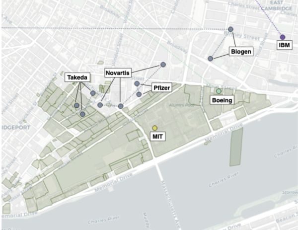
Figure 2: MIT deals land for war and medical apartheid. A subset of MIT’s real estate relationships and partnerships with pharma, weapons developers, and computing corporations in Kendall Square, Cambridge. MIT parcels as of 2021 shown in green (data from MassGIS).
MIT has also built a joint laboratory with IBM, a company that has helped racist regimes keep records – from the US to the German Nazis and the South African apartheid government. The Hollerith machine, a mechanical tabulator developed in the 19th century that was core to IBM’s founding, offered a way to record people’s race and sex on a large scale for purposes of criminalization. The company has continued to develop tools of repression with more sophisticated computers. IBM helped develop COPLINK, a platform used by police departments across the US to share and analyze records. In Massachusetts, as many as 25 police departments automatically feed most of their data – from arrests, complaints, and citations to interviews with police officers – into COPLINK. IBM also services Israel’s population registry, which the Israeli state uses to issue ID cards. The registry supports a colonial “divide-and-conquer” strategy in which Palestinians are differentially oppressed by Israel based on where they reside (e.g., Palestinians with Israeli citizenship versus Palestinian non-citizens living in East Jerusalem), a distinction which is tracked using IBM’s tools.
Along with war, MIT also allocates space to the companies that sustain medical apartheid, such as Pfizer, Novartis, and Takeda (which bought the Cambridge-based biotech Millennium Pharmaceuticals). During the Covid pandemic, Pfizer cut a deal with the Israeli state: the company provided vaccines for distribution to Israeli citizens (at the expense of Palestinians) in exchange for medical data. Novartis fights to keep drug prices high and to block the production of more affordable generics in the Global South. In 2013, for example, Novartis fought in India’s courts for the right to charge exorbitant prices for Gleevec, a cancer drug. Takeda similarly charges exorbitant fees for cancer drugs while flexing legal muscle to block production of cheaper generics. Like Pfizer and Novartis, Takeda’s expansion, which residents have tried to stop, contributes to the ethnic cleansing of Cambridge’s communities. Harvard has followed a similar strategy when expanding into Allston, where it has built biomedical research facilities – geared towards privatization and the creation of startup companies – against residents’ will.
Replacing the resistance
For the colonial university, Cambridge is a “success” story: if you visit today, you’ll find a booming industry that works for capital and empire, built on the ruins of displaced communities. You’ll see pharmaceutical companies, computing corporations, weapons developers, and secretive weapons research labs such as Draper Laboratory. But what existed before this landscape was reorganized by the land-grabbing machine?
Cambridge was once home to a third of all organizing spaces in Greater Boston, according to local historian Tim Devin who documented a range of mutual aid groups, radical feminist organizations, and tenants’ unions working in the city in the 1970s. “Part of the force of these groups was their visibility,” Devin writes in Mapping Out Utopia, “both in the media, and in the physical space of the city.” The physical visibility of storefront organizing spaces depended upon the cheap rent that existed in Cambridge at that time – cheap rent which was made possible by prior racist redlining and organized abandonment that had devalued real estate in Cambridge’s historically Black and immigrant neighborhoods. As universities expanded into these neighborhoods and displaced their residents, rents increased and many radical groups couldn’t afford to stay.
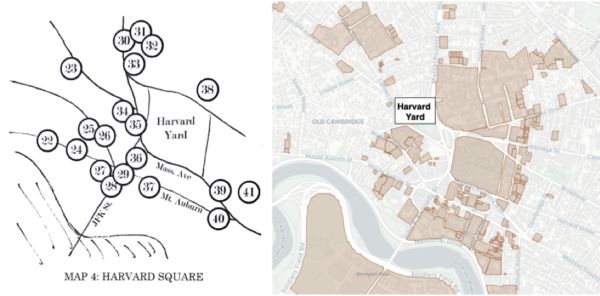
Figure 3: Harvard Square, then and now. Left: Tim Devin’s map of community organizations in Harvard Square in the 1970s (source: Mapping Out Utopia).
The groups mapped by Devin have been progressively replaced (Figure 3). The landlords of Sanctuary (74 Mt. Auburn St), a shelter and provider of counseling services for people experiencing homelessness, sold the building to Harvard in 1974, who terminated the lease; today it houses the Harvard Office for the Arts. A feminist cooperative daycare (46 Oxford St) survived a move into a Harvard-owned building only to become a $2,780/month daycare serving Harvard parents. Other Ways, an alternative school at 5 Story St, was swallowed up by Harvard’s campus. Organizations not directly replaced by universities were destroyed by their effects on the real estate market. In 2015, a triple-decker at 186 Hampshire St that lefty landowners had been renting affordably to radical groups for 40 years was seized by the city for back taxes (for most other landlords, rising property values are enough to kill low rent).
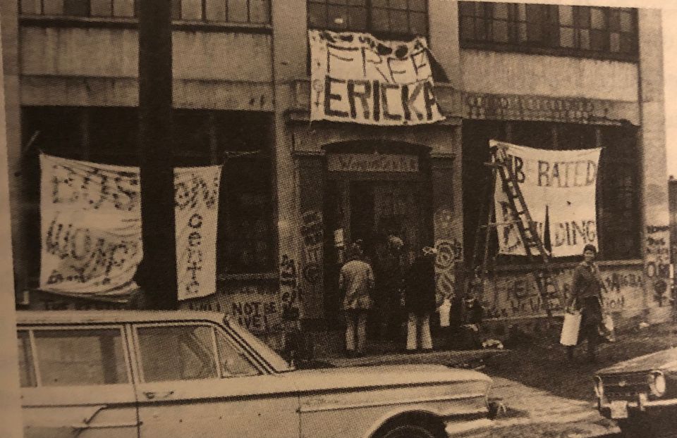
Occupation of a Harvard University building on Memorial Drive, March 1971.
Some organizations held on through struggle, like the Cambridge Women’s Center, which in 1971 raised money to buy their current space through a 10-day occupation of a Harvard building (888 Memorial Drive) that demanded a Women’s Center and more low-income housing. But most oppositional spaces from that period are either gone or transformed into liberal NGOs.
Beyond Cambridge, in those parts of Greater Boston that haven’t been as thoroughly “cleansed,” the struggle to stay continues.
Colonizing Boston in the service of the US war machine
By reshaping city politics, universities have directly contributed to the whitening of the city. But even when universities aren’t directing displacement, their colonial presence sets the stage for it. The resulting increases in property values further enrich the universities as landowners, and enable them to take more resources for war and medical apartheid. Universities’ colonization of Roxbury illustrates this racist feedback loop and its connections to US imperialism.
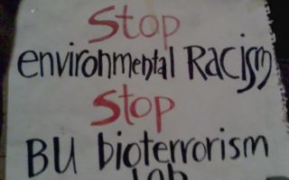
Protest sign against BU's bioterror lab that emphasizes link between bioweapons and environmental racism.
In the early 2000s, Boston University decided to establish a government-funded bioweapons lab called NEIDL (“National Emerging Infectious Diseases Laboratories”) on Albany Street in the South End, at the edge of Roxbury (Figure 4), against the residents’ will. NEIDL cultivates dangerous air-borne pathogens, including Ebola, smallpox, and anthrax – all to enhance the harm capacities of the US war machine. Pathogens and epidemics have long been weaponized by empires for use against colonized peoples and as weapons of counterinsurgency. The US government has grown its biological weapons research since World War II, and has a record of experimenting with bioweapons in urban areas without residents’ consent, especially in Black communities and other communities of color.
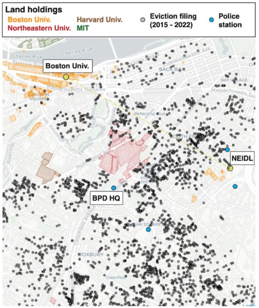
Figure 4: Universities grab land and create private wealth amidst displacement and ethnic cleansing. Universities’ land parcels are color-coded (Boston University’s parcels in orange), black dots indicate eviction filings filed between 2015-2022, and blue dots indicate police stations (data from MassCourts and MassGIS; note location of Boston Police Department Headquarters). Eviction filings are certainly an underestimate of the number of actual evictions, which often take place informally through intimidation, coercion, and/or punitive rent hikes, without leaving a legal record.
Continuing this pattern, the state chose to build one of its most dangerous biolabs in Roxbury. Roxbury’s predominantly Black residents were already suffering from displacement, criminalization, and organized abandonment under racial capitalism. As George Lipsitz writes in How Racism Takes Place, “living in segregated inner-city neighborhoods imposes the equivalent of a racial tax on people of color” – a “racial tax” that manifests in literal harm to “the health and well being of Black bodies.”
Some of the city’s most polluting facilities have been imposed on Roxbury, including power stations, high-traffic bus stations, junkyards, and waste incinerators. The area’s residents lack access to health care and nourishing foods, and parts of Roxbury have the shortest life expectancy in the city (59 years), dramatically lower than that of the wealthy Back Bay area (92 years) which is half a mile away. Roxbury is also where the forces of ethnic cleansing and displacement are most intense. The Boston Housing Authority and real estate companies have been evicting residents in Roxbury at far higher rates than in Cambridge and Somerville (Figure 4).
By fueling displacement and pursuing biowarfare, universities and their corporate-state partners negate efforts to build life-affirming communities. This negation is covered up with propaganda. NEIDL is presented as a “public health” lab that will develop treatments for infectious diseases, and which is entirely “safe.” Yet NEIDL is sponsored by the very entities that block affordable access to medicines and vaccines, such as the Gates Foundation (which also supports bioweapons development) and pharmaceutical companies like Merck and Takeda, and by the US war machine that sucks resources away from communities and pollutes the earth.
Roxbury residents saw through the lies, and tried to stop Boston University’s bioterror lab.
Community resistance to the colonial university
As soon as plans for Boston University’s bioterror lab became known, Roxbury residents organized against it. Stop the BU Biolab, a coalition of Roxbury residents and allies, fought against the lab because of the health and environmental dangers the facility brings, and because of the inherent harm of putting bioweapons in the hands of the state. Chuck Turner, then a Boston city councilor backed by Roxbury residents, repeatedly tried to get the city to ban the lab. The community managed to delay NEIDL’s opening by nearly a decade, until the National Institutes of Health ruled that the lab poses no substantial risks – despite the history of accidents in Boston University’s facilities and other bioweapons labs.
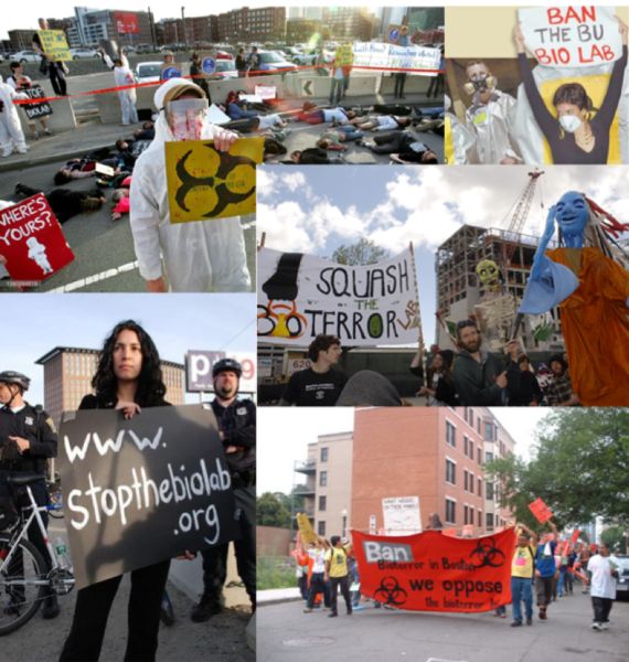
Community protests against BU's bioterror lab (photographs from 2005-2007).
Even some local politicians voiced opposition: at a 2005 protest against NEIDL, then Boston city council member Tito Jackson said, “Our community will no longer get dumped on. We have an expressway, we have all the traffic that occurs in a city in that area, and we also have a prison. We do not need ebola, or whatever other airborne or non-airborne agents in our community.” Organizers have since continued to warn about NEIDL’s harms. As Klare X. Allen told Boston’s WBUR radio station in 2012, NEIDL has failed to address basic questions about the facility, such as “How are we going to be safe? How are we going to eat? How will we be notified [in case of an accident]? Will there be an alarm? How is it going to be transported? What neighborhoods is it going through?”
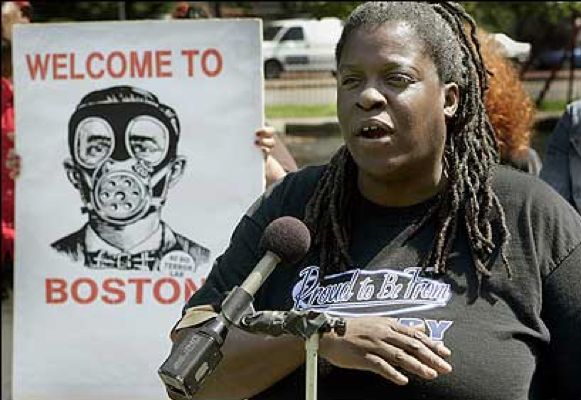
Roxbury resident and organizer Klare X. Allen speaking at a 2006 protest against BU's bioterror lab.
The resistance persists today, as NEIDL continues its secretive operations. The lab has started working with SARS-Cov-2 in recent years, and as expected, it has had a series of dangerous accidents that even made it into NEIDL’s sanitized reports.
Boston University, meanwhile, continues to accumulate wealth. Down the street from NEIDL, on 700 Albany Street, the university has a set of campus buildings that the state of Massachusetts values at over $96 million and that sit on land valued at ~$21 million (as of 2021). Northeastern University also holds expensive real estate in the area (Figure 4). Private wealth is thus being created amidst evictions, criminalization, and organized abandonment by the state. The university drives this violence, both directly through policy (as we have seen) and more indirectly. The accumulation of property invites more policing to protect that property; more policing brings more criminalization and evictions of the “undesirable” residents; evictions clear the way for real estate developers to serve the growing population of university professionals; this population invites more accumulation of property and hence more policing, and the cycle continues.
Yet history shows that this colonial loop can be disrupted. The university’s land-grabbing machine has been challenged at every stage by the organized efforts of the people it seeks to exploit, push out, and harm. We can fight this machine by building local community power, and connecting our struggle for health, housing, and liberation with the struggle against imperialism and war.
Further reading
About US universities displacing and extracting profits from communities
- John Trumpbour (ed), How Harvard Rules: Reason in the Service of Empire (1989)
- Lily Geismer, Don’t Blame Us: Suburban Liberals and the Transformation of the Democratic Party (2014)
- Shin Eun-jung, Verita$: Harvard’s Hidden History (2015)
- Davarian Baldwin, In the Shadow of the Ivory Tower: How Universities Are Plundering Our Cities (2021)
- Stop LAPD Spying Coalition, Automating Banishment: The Surveillance and Policing of Looted Land (2021)
- Bill Cunningham, Belonging (unpublished manuscript).
About bioweapons and Boston University’s NEIDL
- Stop the Biolab website
- “BU flunks the trust test,”Boston Globe (2005)
- “Roxbury, Massachusetts: Direct Action Civics and Biodefense” in Thomas Beamish, Community at Risk Biodefense and the Collective Search for Security (2015).
- “Aberrant Wars” in Harriet Washington, Medical Apartheid: The Dark History of Medical Experimentation on Black Americans from Colonial Times to the Present (2017).
- Mark Wheelis, Lajos Rózsa, and Malcolm Dando, Deadly Cultures: Biological Weapons since 1945 (2006)
Notes
“Land. And the University Is Settler Colonial,” in la paperson, A Third University is Possible (2017); Robert Lee and Tristan Ahtone, “Land-grab universities,” High Country News (April 2020) (see also Land-Grab Universities Map).
Harvard's billion-dollar farmland fiasco. São Paulo: GRAIN & Rede Social de Justiça e Direitos Humanos. August 2018.
These numbers were calculated from estimates of land and building “value” to the capitalist market system, done by the state of Massachusetts (source: MassGIS).
Zachary Robinson and Oscar Hernandez, "Neighborhood Bully: Harvard, the Community, and Urban Development," in John Trumpbour (ed), How Harvard Rules, 190.
Bill Cunningham, Belonging (unpublished manuscript), 43; How Harvard Rules (1989), 182-184
As Zachary Robinson and Oscar Hernandez write, “Perhaps city-wide at large elections [as implemented by Plan E] are not inherently anti-democratic, but at the time it had that effect…Plan E changed the tone of politics, creating a sort of mysticism of the professional municipal problem-solver. It changed the focus of politics towards highly organized interest groups.” (How Harvard Rules, 185).
“The University today is in the position of a man about to be eaten by cannibals… The fully matured product is visible in a slum-surrounded university like Columbia or Chicago.…It is hard enough to find good teachers. Inducing them to live in slums is next to impossible.…The only alternative is to attack the existing pattern, to develop a new pattern through urban renewal.…Harvard cannot be fitted to a slum community, and Harvard cannot move.” (Belonging, 44)
At the same time, “Harvard opened its own planning office, ‘to work closely with the city manager and his urban renewal assistant’” (Belonging, 43).
Belonging, 49-50; “Throughout the postwar era, MIT boasted the largest defense research budget of any university, with neighbor Harvard following closely behind in third place.” (Lily Geismer, Don’t Blame Us, 21). See also How Harvard Rules, 186.
Jon Pynoos, Housing Urban America, 58.
The Inner Belt (I-695) was a ring road highway proposed to link I-95 to Boston, Brookline, Cambridge, and Somerville under the eminent domain powers of the 1949 Housing Act. A cross-neighborhood coalition of residents succeeded in getting the project canceled in 1971, thereby preventing massive clearance of central Cambridge and southern Somerville neighborhoods – but not before neighborhoods in Roxbury had been leveled along what is now Melnea Cass Boulevard (Karilyn Crockett, People before Highways).
“Seek Houghton School Site Which Won’t Involve Homes,” Cambridge Chronicle (March 3, 1966):1.
In the words of Thomas O’Brien, vice president for financial affairs at HRE in the 1980s: "In the long run the University may have the need to use its properties in other ways that they are currently being used… When property is available at a reasonable price it has thus been sensible for the University to buy it.”
How Harvard Rules, 194; Belonging, 107, 158.
According to a paper by MIT economists, written for the National Bureau of Economic Research, the “gentrification” produced by “rent deregulation” (abolition of rent control) reduces “crime.” They write: “Our findings establish that reductions in crime are an important part of gentrification and generate substantial economic value.”
“A Hedge Fund With Libraries: The Financial Crisis of 2008,” in Shin Eun-jung, Verita$: Harvard’s Hidden History (2015).
“Aberrant Wars” in Harriet Washington, Medical Apartheid: The Dark History of Medical Experimentation on Black Americans from Colonial Times to the Present (2017).
“Roxbury, Massachusetts: Direct Action Civics and Biodefense” in Thomas Beamish, Community at Risk Biodefense and the Collective Search for Security (2015).
What is the Mapping Project?
Welcome to the Mapping Project. We are a multi-generational collective of activists and organizers on the land of the Massachusett, Pawtucket, Naumkeag, and other tribal nations (Boston, Cambridge, and surrounding areas) who wanted to develop a deeper understanding of local institutional support for the colonization of Palestine and harms that we see as linked, such as policing, US imperialism, and displacement/ethnic cleansing. Our work is grounded in the realization that oppressors share tactics and institutions – and that our liberation struggles are connected. We wanted to visualize these connections in order to see where our struggles intersect and to strategically grow our local organizing capacities.
Our interactive map illustrates some ways in which institutional support for the colonization of Palestine is structurally tied to policing and systemic white supremacy here where we live, and to US imperialist projects in other countries. Our map also shows the connections between harms such as privatization and medical apartheid, which are often facilitated by universities and their corporate partners. Since local universities engage in these multiple forms of oppression and produce much of the ruling class, and because they are major land holders in our area, we've emphasized the university as a central nexus that ties together many of the harms traced on the map. (For more on what we think the map reveals, see What We See page and read our articles.)
We acknowledge that our map is not a complete representation of local institutions responsible for the colonization of Palestine or other harms such as policing, US imperialism, and displacement. We also recognize that the struggles of local Indigenous nations against US colonization are underrepresented on our map. We would be grateful for suggestions and knowledge shared with us by those who engage with our map, and hope it can continue to grow and improve through your contributions.
This map is intended first and foremost to cultivate relationships between organizers across movements and deepen our political analyses as we build community power. Building community power, for us, has meant seeking the knowledge of those organizing in community with us and highlighting the radical analyses and resistance of earlier generations which have been suppressed.
Our goal in pursuing this collective mapping was to reveal the local entities and networks that enact devastation, so we can dismantle them. Every entity has an address, every network can be disrupted.
Inside the War Tearing Psychoanalysis Apart: 'The Most Hatred I’ve Ever Witnessed'
A professor was accused of antisemitism. The controversy has exploded into a bigger, messier debate about the future of psychology itself
by J Oliver Conroy
The Guardian
June 16,2023
